Topography, Architecture and Socio-historical Structure in East Crete, during the Bronze Age
Giorgos Vavouranakis
This webpage presents the results of a research project of the Faculty of History and Archaeology of the National and Kapodistrian University of Athens. The project took place during the years 2003-2005 and its subject was the historical and social importance of the relationship between monuments and landscape in Crete during the Bronze Age. It has been argued that the landscape was both the medium and the outcome of human agency. Architectural monumentality played a special role in this dialectic relationship as it selectively highlighted different aspects of the landscape during each historical period. Based on this theoretical frame the project examined case studies from archaeological sites and, specifically, the Prehistoric cemeteries of Gournia and Mochlos, as well as the peak sanctuary at Petsofas. The analysis of the case studies benefited from digital photorealistic reconstructions.
Previous Research
There is ample evidence to suggest that the Bronze Age inhabitants of Crete imbued the places they dwelled with meaning. Thus, these places were rendered social constructions, which maintained an active role in the reproduction of the social web. This meaningfulness included the natural environment, since the latter appears in Minoan art markedly. For example, the Kamares ware and the floral and marine pottery styles and also many frescoes and seals depict features of the natural environment, either isolated or in landscape compositions. It is particularly interesting to note the relation of these depictions with the palatial power. Frescoes are found mainly in palaces and villas. Decorated pottery is of high quality and almost exclusively accessed by persons and groups of high social status. Finally, seals are objects that indicate social status. As a result, there is a clear link between landscape iconography and social power and authority on Crete.
This connection was probably filtered through religion, since the natural world is considered to have attained a special place within Minoan metaphysical beliefs. Themes, such as the bull, the snake goddess and the tree are considered to be powerful religious symbols. Religion was interweaved with political authority, too. The ‘palaces’ included a powerful religious component through their sanctuary areas. Furthermore, indications of the interweaving between religious practice and socio-political structure come from peak sanctuaries. These places were used for popular ritual performances in the Middle Minoan period, but their number decreased significantly during the Late Minoan I. The ones that remained in use seem to have passed into the sphere of influence of palatial elite groups.
As a result, there seems to have been a complex and, at the same time, significant relationship between man and environment in Crete during the Bronze Age. The natural environment was more than a backdrop for human activities. Agency rendered it a meaningful landscape, namely a bearer of collective values, which defined social action. The landscape then was an active constituent of Minoan society. The present research focuses upon this complex relationship between landscape and society.
Aims and Methods
The historical and social reverberations of the relationship between monuments, landscape and Bronze Age society in Crete are examined through a special emphasis upon a pattern of changes observed in the archaeological record of east Crete. More specifically, tombs were relatively monumental in the Prepalatial period. They were built above the ground, either in the shape of a stone vault or, usually, in the shape of rectangular room, while they were placed on elevated places or places visible in the landscape. Settlements, however, were small. This pattern changed in the Middle Bronze Age and was completely reversed in the Late Bronze Age, and specifically in the Neopalatial period. The dead then were placed in unmarked shallow pits or in old tombs, which either continued to be used or had been abandoned and then were reused. On the other hand, the world of the living acquired a prominent place in the landscape, due to the rebuilding of the palaces, the appearance of the villas and the development of urban settlements.
The above pattern of historical evolution suggests that it is possible to understand historical and social changes in Crete by correlating changes in topography and architecture. Thus we see a transformation from the landscape of dead ancestors to the landscape of the daily activities of the living. This transformation is in agreement with the view that architecture shapes space into place, since it provides the necessary material cues that dictate, although they do not necessarily define, the appropriate behaviour in each place. In this respect, architecture participates in the dialectic relationship between human action and place, since it shapes and at the same time is being shaped by both members of this relationship. Within such a dynamic process architecture selectively highlights aspects of human agency, since it is impossible to contain all aspects of human agency within a given built place. As a result, architecture shapes the landscape because it affects the ways in which the landscape is lived and imbued with meaning. Architecture then is a frame, wherein the social subject is placed and understands his/her place and way of action.
The examination of the relationship between landscape, architecture and social structure revolves around specific methodological and practical questions. What is the place of monuments in regard to natural topography and visibility? Are they situated close to roads, harbours or other places of human traffic? Do architectural structures fit into the natural environment or do they stand out of it? What does the comparison of monumentality between tombs and other structures show in each time period? How often may it be assumed that people visited tombs and for what reasons?
The research project examined specific case studies according to the above questions. These case studies are the cemetery of Mochlos, the North Cemetery of Gournia and the peak sanctuary of Petsofas. The selection was not random. All three examples are related to ritual activity, and within its frame worldviews, attitudes and social relations are frequently (re-) negotiated, with the result of the active emplacement and function of the landscape within the social happenings. Furthermore, the selected sites cover almost all the Bronze Age, especially the period before and during the time of the palaces (approx. 3000-1450 BC). Finally, there is adequate information for all these monuments through final site reports and additional studies.
Gournia
 |
| Fig. 1. Map of Gournia. |
Gournia is situated almost at the base of the gulf of Mirabello, exactly to the west of the most fertile flat area of Crete, namely the isthmus of Ierapetra (Figure 1). The area of Gournia is lowland, unrestricted by mountains, with the exception of its south side. Its east and west borders are low hills, which frame an area rich in archaeological remains, since the main settlement lived throughout the Bronze Age, while a ‘palace’ was built during the Late Minoan I period. Within the fame of the current project only the North Cemetery was selected for study. It is situated on the slope of a natural spur to the north and comprises eight tombs, out of which only four are visible today (Figure 2).
 |
| Fig. 2. Photograph of the area of Gournia. The settlement hill in the centre. The cemetery in circle. View from the North. |
Tomb III is the earliest that is Early Minoan II. It comprises four compartments built along the façade of a protruding rock. Tomb II has been considered to be an example of ‘organic’ architecture. The term describes buildings that are smoothly embedded in their natural environs, because they use the bedrock instead of a back wall. Nevertheless, the final impression of tomb III depends upon the specific reconstruction of its missing façade.
 |
 |
| Fig. 3. Tomb III, North Cemetery, Gournia. ‘Organic’ reconstruction with four entrances and flat roof. | Fig. 4. Tomb III, North Cemetery, Gournia. ‘Organic’ reconstruction with four entrances and stepped roof. |
There are two possible reconstructions of the façade. In the first of the two, each room had its own entrance and the whole building gave a light impression (Figure 3). If the compartments had been added successively, hence the stepped roof, then the impression would have been even lighter (Figure 4). In this case, as at Mochlos, the tomb would have been harmoniously embedded in its natural environment. This way, it would have been easier to metaphorically embed the dead in the landscape, which would thus represent values such as kinship, lineage, tradition and, hence, history and local identity. Through the filter of this charged landscape, funerary ritual would facilitate the (re-) negotiation of roles and resources left by the dead. As a result, it would comprise a space of review of the social reality of the time.
In the second reconstruction (Figure 5), tomb III had only one, central entrance. Here the natural bedrock is not so visible as before. Tomb II becomes a rather distinct human construction than a manmade extension of the natural bedrock. This architectural form essentially prepares the way for the formation of a different attitude towards the landscape that appeared in the Middle Minoan period, where natural features and manmade structures comprised distinct elements of the overall landscape.
 |
 |
| Fig. 5. Tomb III, North Cemetery, Gournia. Reconstruction with a single entrance. | Fig. 6. Tomb I and II, North Cemetery, Gournia. Reconstruction with windows. |
This attitude is clearly reflected upon the Early Minoan III – Middle Minoan I tombs I and II, which are considered to imitate domestic architecture (Figure 6), hence their characterisation as ‘house-tombs.’ A stepped altar and a kernos outside tomb I created a focus of ritual activity in the open space between the two tombs. The characterisation of ‘house-tombs’ has allowed the hypothesis that the world of the dead had become a duplicate of the world of the living, since the former borrowed architectural forms from the latter. According to this hypothesis, it has been suggested that there were two distinct spheres of being and action: one for the living and its copy for the dead. As a result, any differences in the richness of grave goods may be interpreted as a mirror of social differentiation in the world of daily life.
 |
 |
| Fig. 7. Tombs I and II, North Cemetery, Gournia. Reconstruction with entrance but without windows. | Fig. 8. Tombs I and II, North Cemetery, Gournia. Reconstruction without windows or entrance. |
But there are alternative ways of reconstructing tombs I and II, either without any openings (Figures 7 and 8), or with one small opening (Figure 9). The absence of openings would prevent the spilling of unpleasant odour in the open space Furthermore, the reconstruction with a small window has a parallel in tholos tomb Gamma in the cemetery of Archanes. If tombs I and II were not house duplicates, despite any isolated features reminiscent of domestic architecture, then the picture of the social web at Gournia changes. Instead of the idea of the static reflection of social structure in the world of the dead, the central place is occupied by the notion of a dynamic and meaningful landscape. In this landscape architecture was not harmoniously embedded in the natural environment. On the contrary, it would state its presence clearly and emphatically, underlining human agency. The landscape would not incorporate the dead and, thus, it would not symbolise descent or local identity.
 |
| Fig. 9. Tombs I and II, North Cemetery, Gournia. Reconstruction with a small window. |
In conclusion, different tombs in the North Cemetery show different significations of the same place during different periods. It is important to note that these changes in signification revolve around a central location in the Gournia coastal basin, namely a crossroads of pathways from the harbour to the settlement and from the Isthmus of Ierapetra to the settlement again. The central place of the cemetery underlines the power of the image of the landscape that the tombs produced, especially if this image was used as a symbol of the appropriate way that society should have functioned.
Mochlos
The area of Mochlos lies 18 km west of modern Siteia (Figure 10). It is a lowland, coastal basin surrounded by fertile hills and less fertile mountains. There is also an islet just in front of the main coast (Figure 11). Coast and islet were linked with a narrow strip of land in antiquity. The area of Mochlos is particularly rich in archaeological remains, especially as regards the Bronze Age. The main settlement on the south coast of the islet was inhabited throughout the Bronze Age. A craft activity quarter and a farmhouse are situated to the south and southeast of the islet respectively. For the present project, the Early Minoan II – Middle Minoan I cemetery was selected as a case study. The cemetery is situated on the west part of the islet and comprises over thirty tombs. Most of them were built with local schist stone. They usually have one or two compartments.
 |
| Fig. 10. The area of Mochlos from the Southeast |
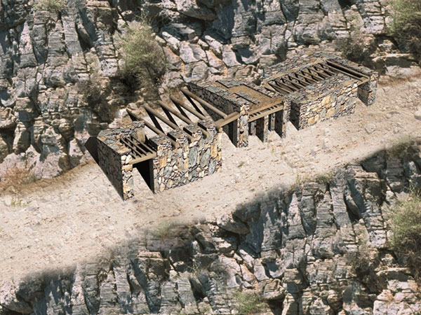
There are two exceptions to the above rule. These are burial complexes I/II/III (Figure 12) and IV/V/VI (Figure 13), which comprise three compartments each. In addition, these complexes are considered to be special as a whole. Both are built on the so-called West Terrace and they seem to comprise a special group of tombs, placed separately from the rest of the cemetery. The main building materials are local, large, schist slabs. These create a multi-colour result and they thus reinforce the elaborate impression of the tombs. The space between the two tombs, and more specifically in front of complex IV/V/VI, had been lined with the same type of schist slabs. It functioned as a gathering area and included a stepped altar just outside the southeast corner of tomb IV/V/VI.
|
|
| Fig. 11. Panoramic view of Mochlos from the South. |
The above features create a rather monumental and elaborate complex, which, nonetheless, is built with local schist slabs and uses the natural bedrock as the backdrop of the buildings. Thus, the built parts resemble extensions of the natural crevices and do not differ from the rest of the place. This respect to the natural topography has been described as ‘organic architecture’ and is of critical importance for the understanding of the social role of architecture at Mochlos. The dead were placed in a re-naturalised place and were metaphorically connected with the natural environment, resulting in the reinforcement of the significance of the place. Funerary ritual was channeled through the prism of a meaningful and dynamic place. This place represented relations of kinship, descent, tradition and history and thus comprised the material expression of local identity.
 |
 |
| Fig. 12. Mochlos cemetery. Reconstruction of tomb I/II/III. | Fig. 13. Mochlos cemetery. Reconstruction of tomb IV/V/VI. |
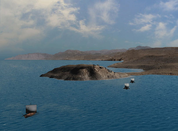
The significance of the cemetery area is stressed by the further examination of topography. The west winds that dominate the area led the boats coming to Mochlos either – and usually – in front of the cemetery, around the islet and into the east harbour (Figure 14), or – more rarely – straight south of the cemetery, where a second harbour might have existed (Figure 15). The cemetery was essentially the gateway to the community of Mochlos, whose economy was based upon the import of raw materials, such as gold, silver and semi-precious stones, with which they crafted objects of high value. These artefacts, after various stages of use and repair, were finally deposited in the cemetery, within the frame of funerary ritual activity. As a result, imported raw materials completed a cycle of life within Mochlos. Both the beginning and the end of this cycle and by extension of the cycle of economy were at the cemetery, a fact that further underscores the importance of this place.
 |
 |
| Fig. 14. Sailing to Mochlos. Reconstruction. | Fig. 15. Possible west harbour at Mochlos. Reconstruction. |
In conclusion, the natural environment at Mochlos was not simply the passive backdrop of human activity. It was a meaningful and active node of the social web. On the one hand, the cemetery occupied a key-position that is the entrance to the harbour. On the other hand, architecture was strategically employed in order to create an arena of social action. Within this arena, funerary ritual renegotiated the structural parameters of the economic and, by extension, of the social life of the Mochlos community. The landscape incorporated the ancestors, who were promoted as the natural protectors of society and the guarantee of descent and tradition.
Petsofas
 |
| Fig. 16. Map of the area of Palaikastro. |
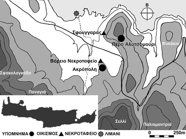
Petsofas is a mountain peak in the area of Palaikastro, a coastal lowland area, similar to Gournia and Mochlos, but wider and less bounded by mountains, with the exception of its west side (Figure 16). An extensive settlement flourished at the site of Roussolakkos, between the Early Minoan II and the Late Minoan IIIB period. The knolls and hills that surround Roussolakkos were used as cemetery areas during the same time period (Figure 17).
 |
| Fig. 17. Palaikastro: the Roussolakkos area in the centre and the Petsofas peak at the back. View from the Northeast. |
During the Early Minoan III – Middle Minoan I, a sanctuary was established on the peak of Petsofas. Ritual practices included the deposition of clay figurines of bulls, of men and of women. Petsofas, together with other peak sanctuaries, is a key to understanding social processes in Middle – Late Minoan I Crete. One of the main features of these worship areas was the fact that they were initially naturally demarcated spaces, with very little or no architectural intervention at all. As a result, the ritual activity for the (re-) negotiation of worldviews, attitudes and social relationships was channeled through the multiple experiencing of the natural environment. Such landscape experience included the ascent to the mountain of Petsofas, as well as a spectacular, almost panoramic, view of the area of Palaikastro (Figure 18). This way of viewing the landscape with its broad scope was entirely different from the perception that daily routine allowed. After all, ritual activity is by definition a special aspect of human agency.
 |
| Fig. 18. The view to the area of Palaikastro from the peak sanctuary at Petsofas. View from the South. |
During the Late Minoan I period, the enclosure of Petsofas was replaced by a built annex of at least five rooms. It was probably built of local stone, which is abundant in the area. The front wall of room I is still preserved at a height of 1,80-1,90 m (Figure 19). It used to be preserved higher, that is 2,50 m. This wall provides a general impression of the total height of the building. Its reconstruction has been based on the published ground plan, recent site photographs, as well as representations of sanctuaries in Minoan art (Figures 20-23).
 |
 |
| Fig. 19. The architectural remains at Petsofas, from the West. | Fig. 20. The peak sanctuary at Petsofas: reconstruction with a tripartite building and small horns of consecration. |
 |
 |
| Fig. 21. The peak sanctuary at Petsofas: simple reconstruction. | Fig. 22. The peak sanctuary at Petsofas: reconstruction with a simple building and large horns of consecration. |
The addition of the built annex is a common characteristic of the few peak sanctuaries that were not abandoned after the end of the Middle Bronze Age. It may also be considered as part of the wider tendency of the Neopalatial period to underscore the importance of the world of the living in contrast to the world of the dead, through an architectural intensive activity, which included the erection of palaces, villas, farmhouses, extensive settlements and hamlets, but almost no tombs. Burials were usually restricted in shallow pits, caves, rock shelters and smaller rock niches and ledges. It seems that the living wished to differentiate themselves from their natural environment without, however, including their dead, in this movement. Their attitude towards the landscape is in sharp contrast to the attitude of the Early Bronze Age, when the exact opposite happened: tombs comprised the most monumental complexes in the landscape, while architecture and natural environment were harmoniously linked.
 |
| Fig. 23. The peak sanctuary at Petsofas: reconstruction with a tripartite building and medium horns of consecration. |
This contrast between the Early and Late Bronze Age is reflected in a rather typical manner at Petsofas. This site is a characteristic example of the transformation of human attitudes to the landscape. This transformation started in the Middle Bronze Age as an emerging duality of natural environment and human agency, but it seems that this duality evolved into an asymmetrical relation, with human agency assuming the main part during the Late Bronze Age.
Acknowledgements
The project was co-financed by Greek national funds and the European Commission – European Social Fund. Eleni Mantzourani, Professor of Prehistoric Archaeology was the project supervisor. Chrysanthos Kanellopoulos, Lecturer in Classical Archaeology and Platon Konstantopoulos created the digital reconstructions.
Author
Dr. Giorgos Vavouranakis
Lecturer in “Prehistoric Aegean: Theoretical Archaeology”
National & Kapodistrian University of Athens
gvavour [at] arch.uoa.gr
Indicative Bibliography